


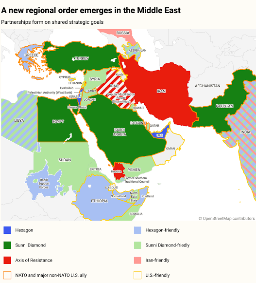


Israeli Prime Minister Benjamin Netanyahu presented a map depicting security developments and political alliances across the Middle East and the Horn of Africa, placing Somalia and its regional administrations within a sensitive geopolitical framework.
The map highlighted Puntland and Somaliland in light blue, which the map’s legend designates as territories viewed by Israel and the United Arab Emirates as allies.
Conversely, Somalia and the SSC-Khatumo (North East) administration were shaded light green, linked to an alliance dubbed the ‘Sunni Diamond,’ which the map noted includes Turkey, Egypt, Saudi Arabia, and Pakistan.
This map was displayed behind Netanyahu as he addressed threats to Israel’s national security and opportunities to expand regional partnerships.
This development has raised questions regarding how Israel views Somalia, the UAE’s influence in Puntland and Somaliland, and the political implications of depicting SSC-Khatumo separately from Somaliland.
A prominent feature of the map is the inclusion of Puntland within the zone designated as friendly to Israel and the UAE.
Puntland maintains long-standing security and economic ties with the UAE, particularly regarding the port of Bosaso, military training, and security operations.
These ties afford the UAE significant economic and strategic leverage in northeastern Somalia.
Somaliland appears on the map under a different context than Puntland, following Israel’s announcement on December 26, 2025, recognizing Somaliland’s independence.
That move sparked intense diplomatic controversy, with the Federal Government of Somalia rejecting the recognition and reiterating its commitment to preserving Somalia’s unity and territorial integrity.
Somaliland is strategically situated along the Gulf of Aden near Yemen and the Bab al-Mandab strait—a vital corridor for international maritime trade, shipping security, and regional power competition.
The UAE also maintains economic and strategic interests in Somaliland, notably through its investment in the port of Berbera via DP World.
The alignment of Israeli and Emirati interests in the region may explain Somaliland’s placement within the map section highlighting partner territories.
However, the map alone does not confirm any specific bilateral agreement between the entities.
Another notable aspect is how the map depicts SSC-Khatumo (North East Somalia).
The area was categorized within the green sector linked to the ‘Sunni Diamond’ alliance, whereas Somaliland was marked in blue.
This distinction illustrates how the map categorizes political factions and territories based on its assessment of regional alignments.
This issue touches on sensitive territorial disputes in northern Somalia, particularly across the Sool, Sanaag, and Cayn regions, where competing views persist regarding governance and borders.
Somaliland claims the borders of the former British protectorate, whereas SSC-Khatumo aligns with the Federal Government of Somalia.
Consequently, representing the two areas separately on a map carries political significance, though it does not alter the legal status of the territory or determine sovereignty.
Crucially, the map originates from an analytical study authored by Marc Saxer and Marcus Schneider, published by the Friedrich-Ebert-Stiftung in May 2026.
Thus, the graphic represents political analysis rather than a legal instrument defining state boundaries.
The map links Somalia and SSC-Khatumo to the ‘Sunni Diamond’ concept, which includes Turkey, Egypt, Saudi Arabia, and Pakistan.
These nations maintain distinct interests regarding regional security, the Red Sea, and the Middle Eastern balance of power.
Turkey maintains extensive defense and economic cooperation with the Federal Government of Somalia.
Egypt focuses on Horn of Africa security and Nile water security. Saudi Arabia prioritizes Red Sea maritime stability, while Pakistan maintains diplomatic and security interests across the Muslim world.
However, the ‘Sunni Diamond’ label used in the map does not in itself establish that these four nations operate under a unified military treaty or maintain identical postures on Somali affairs.
The map offers a conceptual framework of evolving regional alignments, though these relationships remain bound to each nation’s specific national interests.
The UAE has systematically sought to project economic and strategic influence across the Horn of Africa through investments and security partnerships in key ports and maritime infrastructure.
Bosaso and Berbera hold major geopolitical value due to their proximity to vital global shipping corridors.
The UAE’s relationship with Puntland has also emerged as a political factor influencing relations between Garowe and Mogadishu, particularly regarding security pacts, port management, and federal jurisdiction over international agreements.
Similarly, UAE engagement with Somaliland centers heavily on the port of Berbera and commercial operations there.
Viewed through Netanyahu’s map presentation, the UAE serves as a key variable in understanding why Puntland and Somaliland were categorized within specific regional alignment blocs.
The Horn of Africa functions as a strategic bridge linking the Red Sea, the Gulf of Aden, and the Indian Ocean.
The Bab al-Mandab strait remains essential for maritime traffic connecting Asia, Europe, and Africa.
Israel seeks to secure Red Sea transit routes and mitigate threats to commercial shipping.
Somaliland’s position across from Yemen gives it specific relevance to maritime security along that corridor.
For its part, the UAE maintains commercial, port, and security interests spanning the regional coastline, while Turkey and Egypt aim to safeguard their security interests and political leverage.
Somalia thus sits at the intersection of competing global interests. While the map attempts to illustrate how these actors align from an analytical perspective, it does not confirm formal, joint policy decisions among all parties.
Graphics of this nature can reignite debates over Somali unity, federal-state relations, and the authority of regional administrations to enter into independent agreements with foreign entities.
Presenting such a map during a high-level briefing on Israeli national security carries political weight, reflecting how strategic leadership visualizes regional dynamics and interests.
Nevertheless, analytical map depictions must be distinguished from formal diplomatic determinations.
The map does not alter recognized international borders, nor does it confirm that Puntland has entered into formal agreements with Israel.
For Somalia, this highlights the necessity of a unified foreign policy, sustained dialogue between the federal government and regional states, and a clear framework for managing foreign investment and security agreements.